www.kurbaria | home
Introduction | General | Land | Health | Travel | Accommodation | Ressorts and Excusion | Geograph and Climatic | social and business profile | history | Government | Embassies and Consulates | over view | Duty Free/ PublicHolidays
Geograph and Climatic
Eritrea comprises three main geographical and climatic zones : the Eastern Slope and the Coastal Plains, the Central Highlands, and the Western Lowlands.
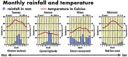
Much of the eastern slope and coastal plains is desert or semi-desert, inhabited mainly by agro- pastoralists. There is a narrow band of fertile agricultural land north and west of Ghinda (small village located 45 km east of Asmara) on the eastern slope. The hottest months along the coast are June through August, where daily temperature ranges from 29° to 41° C, with high humidity (above 80%). During the cool season from December to February, daily temperature ranges from 18° to 32°C. Along the northern coast, the rainy season stretches from December to February. Rain rarely falls along the southern coast.
The highland areas of the country are densely populated and intensively cultivated by farming communities. This area enjoys a temperate climate, with high temperatures of around 29°C during the hottest month of May. The coldest months are December and February with low temperatures around 0°C. There are two rainy seasons, March/April and June through September).
The western lowlands begin in Keren and extend westward to the border with Sudan. Extensive agricultural development is planned for this area which will be irrigated from the seasonal Barka and Gash rivers. High temperature in this region can reach 43°C from April through June. December is the coldest month when temperature may fall as low as 13°C. The rainy season in this part of the country falls from late June to early September, similar to the Highlands.